Take a Hike, Get a Medal
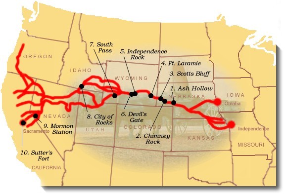
The California Trail begins in Independence, Missouri and travels into Kansas then up to Nebraska where it unites with another branch coming from Omaha. From there settlers followed the Platte River across Nebraska into Wyoming. Once at Ft. Bridger, in western Wyoming, the trail splits into four main branches and travels through Idaho and Utah into Nevada and finally over the Sierra Nevada to California. Several Branches of the trail travel through Utah. We will focus on this part of the California Trail.
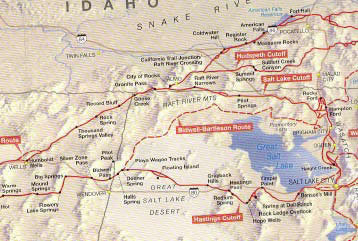
North • Salt Lake Cutoff
There three main spurs that leave Salt Lake City. The northern route is called the Salt Lake Cutoff and follows the northern border of the state up into Southern Idaho to Almo and City or Rocks. From there the trail follows a series of creeks and spring down to Wells, Nevada and picks up the Humbolt River. The trail parallels Interstate 80 from Wells to Carlin where it joins the Hastings Cutoff route.
Central • Bidwell-Bartleson Route
The central trail leaves Salt Lake, heads north to Brigham City and then follows what would become the railroad route along the northern shore of the Great Salt Lake, across the Promotory Mountains and joins the Hastings Cutoff at Donner Spring.
South • Hastings Cutoff
The southern route is called the Hastings Cutoff and follows the southern border of the Great Salt Lake out on to the salt flats roughly following the modern day route of Interstate 80. As you leave Utah the trail joins the Bidwell-Bartleson Route and continues southwest along the Ruby Mountains following a series of spring. The trail finally merges with the northern route in Carlin Canyon.
Trip Overview
For scouts living along the Wasatch Front in Utah as well as those in SW Wyoming, SE Idaho
and Nevada we would like to suggest an activity packed trip to the City of Rocks in Idaho. Not only
does it afford camping and rock climbing near the California trail as well as a very rideable mountain
bike route, there are also several points of interest along the way to the trail.
The Trip from downtown Salt Lake City ~ Mileage: 185 miles ~ Estimated Travel Time: 3 hours 40 minutes
Attractions along the way
1. Farmington Bay Wild life Refuge in Farmington, Utah. Just off 1-15, this wildlife refuge
allows you drive along a series of dikes and roads out into the wetlands area for wildlife viewing.
2. Willard Bay near Brigham City, Utah. Great place to stop and boat or swim.
3. Crystal Hot Springs in Honeyville, Utah. Again, just off 1-15, this is a very poplar camping
destination for scout units with younger boys. The hot springs have been tapped and piped into a
cement pond. Great place to relax on the way to or back from the City of Rocks.
4. Golden Spike National Monument in Promontory, Utah. A short detour off 1-15, this is a
National Monument that celebrates the uniting of two railroad lines in 1860, connecting the United
States from coast to coast with a single rail line.
Driving Directions from downtown Salt Lake City (side trips in italics)
Travel 71 miles north on the Interstate 15 to Tremonton
Exit 372 Crystal Hot Springs
Exit 317 Farmington Bay Wildlife Refuge
Exit 357 Willard Bay State Park
Exit 365 Golden Spike National Monument
Take the left split and follow 1-84 for 73 miles to Exit 245
Entrance 26 From Golden Spike National Monument (return to I-84)
Take exit 245 for Sublett Road toward Malta for 4.8 miles
Turn left at 1400 S Road/Sublett Road
Continue on Jane Lane for 1.6 mi
Continue on 4th St North for 1.3 mi
Continue on 5th Avenue for 0.8 mi
Turn left at ID-81/N Main St after 0.5 mi
Turn right at 1st Avenue/Center Street/ID-77
Continue to follow ID-77 for 7.5 mi
Continue on S Elba Almo Road for 15.7 mi
Turn right at 2975 S after 0.7 mi
Turn left at 750 E/Big Cove Rd/Big Cove Ranch Rd/Hoff Ln at 1.1 mi
Turn right at 3075 S/City of Rocks Rd
Continue to follow City of Rocks Rd for 3.8 mi
Welcome to City of Rocks
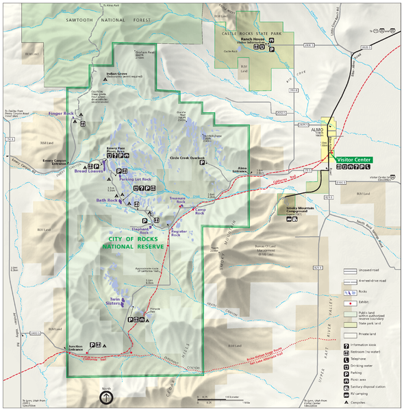
Camp at any of the 75 campgrounds. For the mountain bike ride, start in the city of Almo and ride the dotted path on the map above. Your mileage will be just over 10 miles. Be sure to take time stop at the Visitor’s Center in Almo, Register Rock and the other points of interest (indicated by the dots along the trail). The ride should take you about 3 hours to complete at a leisurely pace.
Camp Details:
Camp in the City of Rocks National Recreation Area
There are about 75 designated campsites in the reserve. Three group sites are available.
There is one potable water source in the reserve. Most of the campsites among the rock formations are
accessed from the road. Sites are equipped with picnic tables and fire rings. There are no hook-ups,
showers or dump stations. Vault toilets are located throughout the reserve. Gathering of fire wood is
prohibited. Bring your own wood or purchase it at the visitor center. Backcountry permits are free and available
at the visitor center
Camp Reservation Number: 1-208-824-5519.
Fee: $ 7.00/Campsite
Extra Vehicles at Campsite: $ 5.00 each
Sites: Bath Rock 1-3, Elephant Rock, Parking Lot Rock, Bread Loaves, Twin Sisters, South Entrance
Mountain Bike Ride
Mountain Bike Ride: 10 Miles along the California Trail
Begin at city of Almo and ride along the roads near the red dashed path.
or
Hike: 10 Miles along the California Trail
Begin at city of Almo and hike as close to the red dashed path on the map.
Interpretive Center
Visit the Interpretive Center at the City of Rocks
Phone Number: 208-824-5519
Address: 3035 Elba-Almo Road in Almo, ID 83312
Hours: 8:00 AM to 4:30 PM
Open: Year Round in Summer, Closed for Holidays in Winter
Other Activities
Rock Climbing, Hiking, Backpacking, Horseback Riding, Wildlife Viewing
The Visitor Center Offers Interpretive Programs
Weekend Itinerary
Friday Afternoon:
Drive to City of Rocks
Set up Camp/Eat Dinner
Campfire
Saturday:
Breakfast
Drive to Alba
Hike or Ride Trail
Visit Interpretive Center
Visit Register Rock
Lunch/Break Camp
Drive back to Salt Lake City
The General Route of the Trail
The trail begins in Independence, Missouri and travels into Kansas then up to Nebraska where it unites with another branch coming from Omaha. From there settlers followed the Platte River across Nebraska into Wyoming. Once at Ft. Bridger, in western Wyoming, the trail splits into four main branches and travels through Idaho and Utah into Nevada and finally over the Sierra Nevada to California.
First Explored By
Employees of the Hudson Bay Company and the John Astor Fur Company.
Dates Used
1840-1870
The Purpose of the Trail
The California Trail was one of the main overland routes to guide early American settlers as they traveled west across the United States
The Early History of the Trail
The California Trail was first pioneered by the Hudson Bay Company and John Jacob Astor’s fur company. These two companies sent many expeditions to explore and map the western portion of the North American continent during the first part of the 19th century. This allowed for others to continue their work and begin to establish routes to the west.
How long was the journey from the Missouri “jumping off” place to California or Oregon?
About 2,000 miles
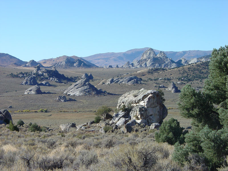
The California Trail winds through City of Rocks Monument in southern Idaho
When did travel on the Oregon-California Trail begin?
In the winter of 1812-13, Robert Stuart and his party returning from Astoria stumbled through South Pass on their way back to the “States.” The effective discovery of South Pass was accomplished by Jedediah Smith and Thomas Fitzpatrick in 1824. The Bidwell-Bartleson Party is generally credited with being the first true emigrant train. It left Missouri in 1841 in the company of the party of fathers Jean Pierre DeSmet and Nicholas Point, guided by Thomas Fitzpatrick. The party split at Fort Hall with some going on to the Snake River and the others opting for the Humboldt River and California. By the time the latter reached California they were no longer a “wagon” train, having been forced to abandon their wagons en route. The first major migration to Oregon came in 1843. Among its prominent members were Peter Burnett, Jesse Applegate and Marcus Whitman. [Merrill Mattes, Platte River Narratives, p. 1]
How many emigrants followed the trails to California, the Pacific Northwest, and Utah?
Probably about 500,000. Perhaps 1 out of every 250 emigrants left some kind of written account. [Merrill Mattes, Platte River Narratives, p, 5.]
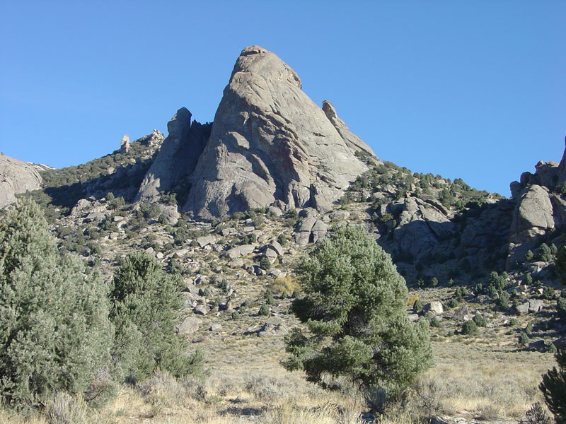
This view is of a great granitic peak on Green Mountain near the Circle Creek Overlook
How long did the trek take, on the average?
Subject to considerable variation because of weather, accidents, etc., on the average a wagon train could expect to be “on the road” 4 1/2 to 5 months. [Greg Franzwa, folio:Newsletter of the Patrice Press, May 1996.]
Firewood along the route.
Timber was noticeably absent on the Platte-Sweetwater route. Just how effective as fuel were the buffalo chips (droppings) most emigrants used as a substitute? It took two or three bushels of chips to heat a meal because chips burned so rapidly. [Merrill Mattes, The Great Platte River Road, p. 57.]
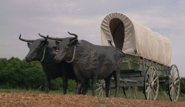
Which type of draft animals were most frequently used by overlanders?
“John Unruh, Jr. and Merrill Mattes, the two premier scholars of westward migration, are in general agreement that oxen were much preferred, with horses and mules considerably less favored. Unruh is content to make the general observation that more than half of all overlanders’ wagons were pulled by oxen, while Mattes cites diary excerpts that suggest a figure closer to two-thirds or three-quarters. The cost of a yoke of oxen during the last half of the 1840s varied from a low of $25 to a high of $65.” [Robert L. Munkres, “Wagon Train Animals,” Annals of Wyoming, Summer/Fall 1993, p 16.]
Oxen were so important to the settlers that the ox yoke was chosen as the symbol for the California Trail logo
Describe a typical pioneer day on the trail.
Many Pioneers had a milk cow tied to the tailgate of the wagon. After milking the cow, the milk sat until the cream raised to the top. Each morning, the cream was poured into a churn carried in or on the side of the wagon. As the churn bounced along over the rough trail, the cream turned to butter. After a few days on the trail, the travelers settled into a well-defined daily routine. Wake before sunup; yoke the oxen, cook the breakfast (usually warm johnnycakes and bacon); and hit the trail. There was an hour break for lunch, and at about 6 p.m., the wagon trains stopped for the night. It is often stated in Pioneer Journals that the wagons were circled to provided a corral for the livestock. In small trains this may be true, but a wagon train of say one hundred wagons would have at least four-to-six hundred oxen or more, milk cows, and saddle horses. A hundred wagons could not make a circle big enough to hold that many animals, and even if it did, what did the animals eat? The grass in the circle would be tramped down and covered with several inches of manure in a matter of hours. In the vast semi-arid areas of the Oregon Trail, animals would have to eat at least ten-to-twelve hours at night to have enough strength to pull the wagons and produce milk. [Historical Facts of the Oregon Trail and America’s Manifest Destiny by O. Ned Eddins]
Many emigrant diaries note the sighting of buffalo
Does anyone know just how many bison actually did exist before the flow of pioneers into the American west? Not exactly! You have your choice of estimates. Francis Haines says there were about 40 million head occupying almost half of the North American Continent. Charles M. Robinson indicates that some estimates run as high as sixty million and E. Adamson Hoebel and Ernest Wallace report estimates of at least 100 million. [Francis Haines, The Buffalo: The Story of American Bison and Their Hunters from Prehistoric Times to the Present, p. 3]
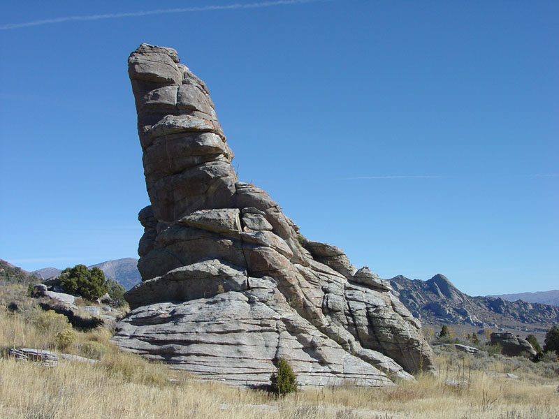
Private Idaho is an unusual Idaho-shaped outcrop of granite near the southwest corner of the City of Rocks
The Donner Party
Hastings thought that he had found a faster shortcut through Nevada than the one that the California Trail was already using. One group, the most famous group to travel along the Trail, the Donner Party, decided to try this new route out. However, the group took an addtional three weeks on this “shortcut” due to difficulties in crossing the Wasatch Mountains and the Great Salt Lake Desert. Because of these setbacks the Donner Party was delayed considerably in their progress. As they were crossing the Sierra Nevada in October they were caught in a pass by a snowstorm and trapped there. Many of the pioneers died in the pass, of the 87 only 48 survived, and it is widely believed that almost all of these people had resorted to cannibalism to survive. They were finally saved due to relief efforts launched by the Californians who were already settled in the Sacramento valley and had heard of the tragedy.
End of the Trail
The California Trail was eventually replaced by the Trans-Continental Railroad, seeing as this provided a much faster way to move west than pulling a cart. The Trail provided an amazing legacy, as wagon ruts can still be seen in some places, and names and dates are still inscribed on rocks at the City of Rocks National Monument in Idaho, pictured below. The trail was also the basis for other roads like Highway 40 and Interstate 80. But the most enduring part of its legacy are the western states themselves. Without the California Trail settlement of the west would have been much slower or may have not occurred at all. The California Trail is a very important and significant part of American History.
Books
Historical Societies Affliated with Trail
Reenactments Near Salt Lake City, Utah
National Park Service
Interpretive Centers Near Salt Lake
Maps on this website
"Yup, that's a long trail ya got there partner"
| A. | Camp 2 days and 1 night along or in the vicinity of the trail. | ||||||||
| B. |
Travel the Trail Using One or More of the Choices Below
|
||||||||
| C. | Study the History of the Trail and Complete the Trail Quiz | ||||||||
| D. | Visit an Interpretive Center or Historic Marker |